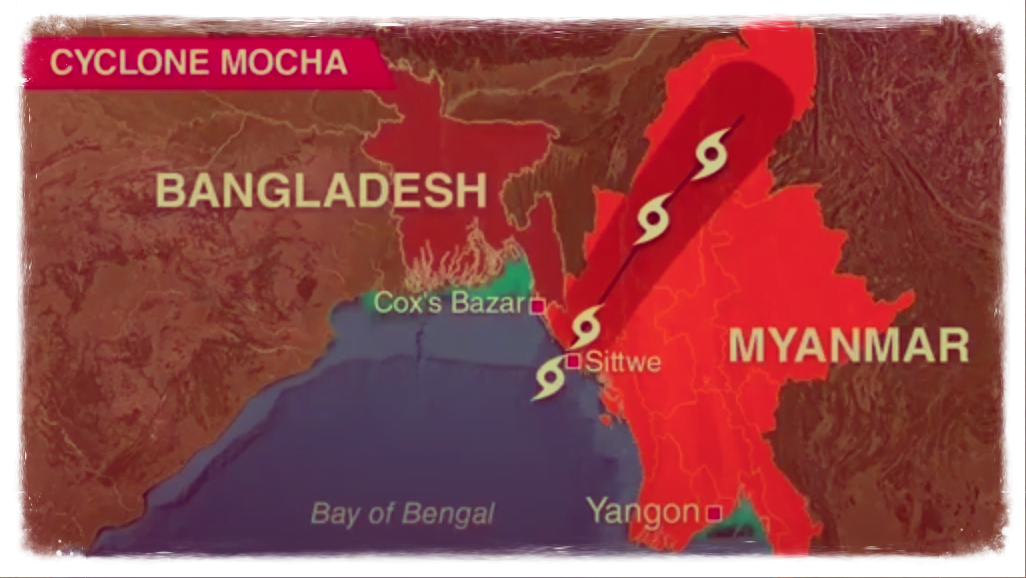
On May 13, 2023, Cyclone Mocha developed as the second most severe cyclone to form in the Bay of Bengal in a single month since 1982. According to Vineet Kumar Singh, a researcher at the Typhoon Research Centre at Jeju National University in South Korea, Mocha increased during the course of 24 hours, going from category 1 (120 km/h) to category 4 (212 km/h).
Mocha became an Extremely Severe Cyclonic Storm on May 13 and may transition into the strongest category of “super cyclone” right before making an impact.
It began building on May 11 over the southeast Bay of Bengal and is predicted to reach landfall on May 14 between Kyaukpyu in Myanmar and Cox’s Bazar in Bangladesh.
Climate expert Raghu Murtugude of the Indian Institute of Technology in Bombay and the University of Maryland told DTE that the hurricane might fall into this category right before making landfall. The warm Bay of Bengal and the slow motion of Mocha are the causes, he explained.
The weather system did not travel as far west as initially forecast, according to Mr. Murtugudde. It is therefore already traveling east towards Myanmar.
Private weather forecaster Skymet Weather reports that on May 12, a tropical cyclonic storm developed an eye, indicating the presence of extremely powerful winds circling the center.
“Ocean heat has predominated, and the warm sea surface has played a significant role in its intensification,” it read. The environment is only sluggishly conducive to any more development.
According to Skymet Weather, “intrusion of dry air, increased wind shear, and rugged terrain” will cause the cyclone to weaken slightly before it reaches the land.
It is anticipated that the extreme weather system would weaken to a Very Severe Cyclonic Storm with winds gusting up to 180 km/h and a sustained wind speed of 160 km/h. After reaching the coast, the storm will quickly dissipate, according to a statement from Skymet Weather. However, the cyclone’s intensification is likely to cause more destruction in the Northeast than initially anticipated. According to the IMD statement, Northeast India is anticipated to see heavy to extremely heavy rains. Upper Assam, Arunachal Pradesh, Nagaland, Mizoram, and other regions, according to Kashyap, are likely to see the harshest effects. He added that there might be some flooding in the area.
IMD predicts moderate damage to unsecured and loose structures, according to Debasish Jena, an agrometeorology expert with the district agromet unit in Cuttack. Heavy rains may cause some kutcha road breaches, and there is a chance of landslides in sensitive locations.
Aside from the loss of standing crops, the IMD also estimates the uprooting of tiny trees, breaking of tree branches, and damage to trees of bananas, drumsticks, papaya, and other types.
The advice, according to Jena, advises protecting fruit nurseries and vegetable plantations, harvesting mature fruits and vegetables right away, avoiding pesticide and fertilizer spraying, and securing cattle and other livestock in sheds.

